Himalayan Disaster, How Unchecked Development and Climate Change Are Putting Lives at Risk
Introduction
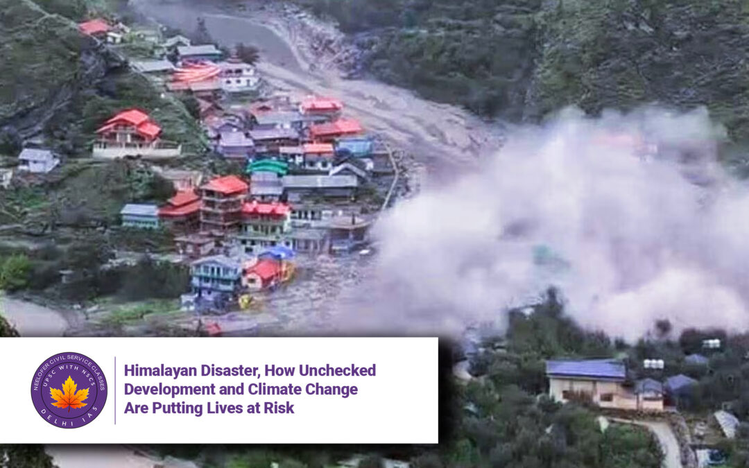
The recent flash floods in Uttarakhand’s Dharaali village are yet another grim reminder of the deadly consequences of ignoring ecological fragility in the Himalayas. What was initially thought to be a cloudburst is now believed to be a glacial lake outburst flood (GLOF)—a phenomenon increasingly linked to climate change and reckless infrastructure development.
This disaster is not an isolated incident. From the 2013 Kedarnath tragedy to the 2021 Rishiganga flood, the Himalayas have repeatedly shown how human encroachment, unchecked construction, and poor disaster preparedness are turning this region into a ticking time bomb.
This article examines:
-
Why the Himalayas are so vulnerable to climate disasters
-
How government projects like Char Dham Highway are worsening risks
-
The failure of early warning systems
-
Why environmental clearances are being ignored
-
What sustainable solutions look like
Why in News?
-
Flash floods in Dharaali (Uttarkashi) on [date] killed [X] people, destroyed homes.
-
Cause: Likely a glacial lake outburst (GLOF), not just a cloudburst.
-
Broader issue:
-
Himalayas warming 0.5°C per decade (twice global average).
-
Glaciers retreating, forming unstable glacial lakes.
-
Unregulated construction (hydropower, roads, tourism) destabilizing slopes.
-
-
Early warning systems failing—only 150 Automatic Weather Stations (AWS) for entire Himalayas (IMD 2020).
Key Issues and Analysis
1. Climate Change: Melting Glaciers, Rising Risks
The Himalayas are the “Third Pole”, holding the world’s largest ice reserves outside the poles. But:
-
Glaciers retreating at 10-20 meters per year (ISRO).
-
Forming unstable glacial lakes—over 5,000 in the region, 200 at high risk of bursting (ICIMOD).
-
Extreme rainfall events up by 30% since 1950 (IMD).
Case Study: Dharaali Flood
-
A glacial lake burst sent water, ice, and debris crashing downhill.
-
Slope steepness amplified destruction—flood wave grew exponentially.
-
Kleer Ganga river changed course due to past landslides, putting villages in danger.
Lesson: Climate change isn’t just about temperature—it’s about altered water flow, erosion, and sudden disasters.
2. Reckless Development: Char Dham Highway & Hydropower Dams
Despite warnings, infrastructure projects are destabilizing the Himalayas:
A. Char Dham Highway (900 km, ₹12,000 cr)
-
Widening roads by cutting mountainsides, causing landslides.
-
No environmental impact assessment (EIA) for segments.
-
Supreme Court intervened, but work continues.
B. Hydropower Projects (Underestimated Risks)
-
Over 100 dams planned in Uttarakhand alone.
-
2013 Kedarnath disaster linked to hydropower blasting.
-
Joshimath sinking (2023) due to tunneling for Tapovan-Vishnugad dam.
Why This Matters:
-
Dams alter river flow, increasing flood risks downstream.
-
Blasting weakens slopes, triggering landslides.
3. Failed Early Warning Systems
-
Only 150 AWS for entire Himalayas (needs 1,000+).
-
No real-time glacial lake monitoring.
-
2021 Rishiganga flood: No warning before dam was wiped out.
Comparison:
-
Bhutan’s GLOF warning system saved lives in 1994.
-
Swiss Alps use sensors, satellite tracking for avalanches.
India’s Gap: Reactive, not proactive disaster management.
4. Weak Environmental Governance
-
EIAs often bypassed for “strategic” projects.
-
No penalties for violations (e.g., illegal resorts in flood zones).
-
Local communities ignored in decision-making.
Example:
-
Musk Deer National Park (Uttarakhand) saw illegal road construction in 2022.
-
NGT fined govt ₹10 crore, but work continued.
Solutions: How to Save the Himalayas
1. Nature-Based Infrastructure
-
Replace concrete with “sponge” zones (wetlands, forests) to absorb floods.
-
Use bioengineering (grass, bamboo) to stabilize slopes.
2. Strict Enforcement of EIAs
-
Independent audits for all projects.
-
Ban construction in high-risk zones (glacial valleys, landslide areas).
3. Better Early Warning Systems
-
Deploy 1,000+ AWS with real-time alerts.
-
Monitor glacial lakes via satellite.
4. Regional Cooperation
-
Himalayan Authority (like EU’s Alpine Convention) for cross-state planning.
-
Community-led conservation (e.g., Ladakh’s ice stupas).
5. Climate-Resilient Tourism
-
Cap visitor numbers in fragile areas (e.g., Rohtang Pass).
-
Promote eco-tourism (homestays, not concrete hotels).
Conclusion: A Tipping Point for the Himalayas
The Dharaali disaster is a wake-up call. The Himalayas cannot be treated as a resource colony or tourist playground. Climate change is accelerating risks, but bad policies are multiplying them.
What’s Needed Now:
✔ Halt destructive projects (Char Dham widening, risky dams).
✔ Invest in nature-based solutions.
✔ Empower local communities as climate stewards.
If India fails to act, the next disaster won’t be an accident—it will be policy failure.
5 Key Questions & Answers
Q1: What caused the Dharaali flash flood?
A1: Likely a glacial lake outburst (GLOF), worsened by slope erosion and river course changes.
Q2: Why are glacial lakes dangerous?
A2: They can burst suddenly from snowmelt/rain, sending deadly flood waves.
Q3: How does Char Dham Highway increase risks?
A3: Deforestation and slope cutting trigger landslides, altering water flow.
Q4: What’s a “sponge zone”?
A4: Natural buffers (forests, wetlands) that absorb floodwater, unlike concrete.
Q5: How can locals help?
A5: Demand EIAs, report illegal construction, revive traditional water management.