What Makes NASA ISRO NISAR Satellite Special?
Why in News
India and the United States are collaborating on a highly advanced satellite mission called NISAR (NASA-ISRO Synthetic Aperture Radar), scheduled to be launched on July 30, 2025, from Sriharikota aboard a GSLV Mk-II rocket. This earth observation satellite will be the first to use dual-band synthetic aperture radar and is set to revolutionize how we monitor and manage natural disasters, agricultural changes, forest cover, and more.
Introduction
NISAR is a landmark collaboration between ISRO and NASA, combining scientific excellence from both agencies to build a powerful, next-generation satellite. The mission is particularly special because of its dual-frequency radar system, a first of its kind globally, which enables the satellite to observe Earth’s surface with unmatched precision, both day and night and in all weather conditions.
The satellite’s capabilities are being hailed as a breakthrough in observing earthquake zones, volcanoes, landslides, ice sheet dynamics, and crop productivity. It will also make data freely available to global users within just a few hours of collection.
Key Issues and Background
What is the need for NISAR?
NISAR will address the global demand for more accurate data on:
-
Natural disasters (earthquakes, landslides, flooding)
-
Human-induced changes
-
Environmental degradation
-
Infrastructure risk mapping
-
Agriculture and forestry management
India’s specific needs—like agriculture monitoring, soil moisture tracking, and land deformation detection—will be directly supported through the L-band radar.
Dual Radar Advantage
-
L-band Radar (1.257 GHz): Penetrates forest canopy and soil, useful for detecting underground shifts, biomass measurement, and crop health.
-
S-band Radar (3.2 GHz): Offers surface-level detail on water bodies, roads, urban infrastructure, and disaster zones.
How Does NISAR Work?
Once in orbit at an altitude of 747 km, NISAR will travel in a sun-synchronous polar orbit with an inclination of 98.4°. Instead of taking photos like traditional satellites, NISAR uses Synthetic Aperture Radar (SAR) to send radar waves to the surface and measure how long they take to bounce back.
This allows the satellite to:
-
Map Earth’s surface in fine detail
-
Penetrate through clouds and vegetation
-
Operate day and night
-
Collect vast amounts of geospatial data
During disasters, NISAR can produce damage maps in under five hours, helping officials and responders take rapid action.
Specific Impacts or Effects
-
Agriculture & Forestry
NISAR will help monitor crop patterns, soil moisture, and forest degradation. Its sensitivity to biomass and soil health will be vital for sustainable land use. -
Disaster Management
The radar can detect land shifts and subsidence with millimeter accuracy, supporting predictions for floods, landslides, and earthquakes. -
Climate Monitoring
By observing polar ice caps, glaciers, and other climate-sensitive regions, NISAR supports global climate change research. -
Urban and Infrastructure Planning
The satellite’s detailed surface maps can guide urban expansion, road construction, and disaster-proof infrastructure.
Challenges and the Way Forward
-
High Sensitivity to Noise: Requires advanced filtering and signal processing to ensure accurate data, especially in urban settings.
-
Data Management: The sheer volume of data (due to the dual-frequency radar) will need fast processing, secure storage, and efficient distribution.
-
Mission Coordination: Smooth coordination between NASA (handling payload and electronics) and ISRO (handling launch, integration, and operations) is crucial.
Despite these challenges, the mission is progressing well. Post-launch, ISRO will handle data dissemination via NRSC (National Remote Sensing Centre) in Hyderabad, while mission control will operate from the ISRO Satellite Centre in Bengaluru.
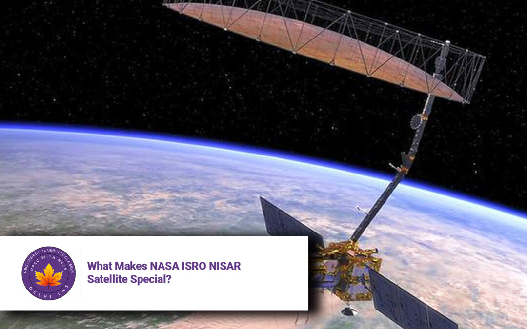
How Was NISAR Built?
At the core of the mission is:
-
NASA-built L-band radar system
-
ISRO-built S-band radar system
-
12-metre diameter mesh reflector antenna
-
A dual-band SweepSAR system
-
Carbon-composite boom and electronics unit
These components were integrated at JPL (Jet Propulsion Laboratory) and then transported to India for full satellite integration.
Conclusion
NISAR is more than a satellite—it’s a technological marvel and a symbol of international collaboration. It stands out as the world’s first dual-band radar satellite, offering applications that will directly benefit farming, disaster management, urban planning, and climate science.
When launched, NISAR will deliver near-real-time data for public use, breaking away from restrictive data-sharing practices of past missions. This move will boost global scientific research and empower countries like India to tackle local challenges with precision technology.
In an era where climate unpredictability and disaster risks are escalating, NISAR’s role will be critical in safeguarding both people and the planet.
5 Questions and Answers
1. What is NISAR and who built it?
NISAR is a joint NASA-ISRO earth observation satellite using dual-frequency radar, with NASA building the L-band radar and ISRO building the S-band radar and handling the launch.
2. What makes NISAR different from other satellites?
It is the world’s first satellite to use both L-band and S-band synthetic aperture radar, allowing deeper and more versatile Earth observations.
3. What are the major uses of NISAR?
NISAR will be used for agriculture, forestry, disaster management, climate monitoring, and infrastructure planning.
4. When and how will users get access to its data?
NISAR’s policy allows open access, with data available to users within a few hours of collection.
5. Where will NISAR be launched and operated from?
It will be launched from Sriharikota (India) on a GSLV Mk-II rocket, and operated jointly by ISRO and NASA from ground stations in India and the US.